
Chilterns Streams
Find out more about the chalk streams which rise in the Chiltern hills.
 Chalk streams are a key feature of the Chilterns National Landscape, with a total length of approximately 150 km. They are important habitats for wildlife, supporting a massive range of plants and animals and are home to some of the areas most threatened species including otter, water vole and brown trout.
Eight major chalk streams have their source within the Chilterns National Landscape, flowing south-eastwards down the dip slope of the chalk escarpment. The Hughenden Stream, River Wye and Hamble Brook flow directly into the River Thames, whilst the River Ver, River Gade, River Bulbourne, River Chess, and River Misbourne flow into the River Colne and then into the River Thames.
In addition, there are many (c. 20) small streams that rise from springs along the base of the scarp slope from the Ewelme Brook near Wallingford in the south to the Barton and Burwell springs, north of Luton. The Ewelme Brook flows directly into the River Thames, whilst the other streams flow north into the River Thame through a predominantly dry landscape.
Find out more
River Ver
The R. Ver rises in the Chiltern Hills close to the Beds/Herts border near Kensworth Lynch, then flows near to Redbourn, and through St Albans before joining the R. Colne near Bricket Wood. It flows for approximately 36km and drops 60m over this distance.
The Ver has one tributary, the River Red, which joins the Ver just south of Redbourn.
The Ver has a rich and varied history. There is evidence of human occupation as far back as 3000BC. The Romans created an important city near the Ver, called Verulamium.
Visit
 The Ver Valley Society has produced a series of walks to encourage enjoyment of the river and surrounding countryside. Ver Valley Walks
The wealth of history along the River Ver provides a good range of places to visit.
In St Albans a large number of Roman artefacts and structures remain. For a good introduction Verulamium Museum is well worth a visit.
Other Roman structures including remains of the city wall, the hypocaust and Roman theatre can be seen around the city.
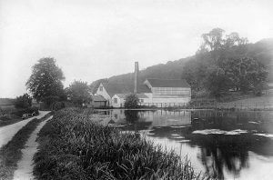
To understand the industrial history of the Ver Redbournbury Mill is worth a visit. This is the last operating mill on the Ver. Here you can buy organic flour or sample the products of the bakery at the cafe.
Get Involved
![]() The Ver Valley Society is an extremely active community group which campaigns for the River Ver. In addition to lobbying work the group carries out practical conservation tasks, controls invasive species, runs events and guided walks and co-ordinates riverfly monitoring along the river.
The Ver Valley Society is an extremely active community group which campaigns for the River Ver. In addition to lobbying work the group carries out practical conservation tasks, controls invasive species, runs events and guided walks and co-ordinates riverfly monitoring along the river.
Issue of low flow
 A lack of flow is one of the key issues faced by the River Ver, much more regularly now than in the past.
When abstraction of the chalk groundwater was at its height, nearly 50 million litres a day were taken for
public water supply – about 50% of the effective rainfall the catchment receives in an average year. The river was the subject of the Alleviation of Low Flows (ALF) initiative in the 1980s after the river dried, but despite some abstraction reductions, it has yet to regain its former character.
Indeed, the Environment Agency’s Environmental Flow Indicator (EFI) estimates that the Ver has a deficit of 24 million litres a day.
The perennial head of the river has moved downstream about 5km (Markyate to Redbourn) in the past 70 years, while in that time abstraction has increased substantially.
River Gade & River Bulbourne
The River Gade is about 25km long and falls 60m on its way to join the R. Colne. The Gade, and its main tributary the River Bulbourne join at Hemel Hempstead. The Bulbourne has a small tributary – the Bourne Gutter. This is a wintebourne and only flows at time of high groundwater.
Of all the Chilterns streams these rivers have suffered the greatest damage by human activity. In addition to the abstraction, modification and culverting suffered by many of the Chilterns Streams, in several places the Gade joins, and is lost entirely to the Grand Union Canal. This has series impacts on water quality and wildlife.
Above Hemel Hempstead the Gade is a high quality chalk stream with mayflies, caddisflies and trout. Further downstream in places where the river is deep and silty have fewer invertebrates and some coarse fish, such as roach, chub, perch, bream and carp.
River Chess
 The River Chess is a clear fast-flowing river which rises north and west of Chesham and flows south east through Chorleywood to join the river Colne at Rickmansworth.
The Chess supports a good range of wildlife, including brown trout, and grayling. The River Chess is the last river in the Chilterns to hold on to a water vole population (although a populations have now be re-introduced elsewhere). 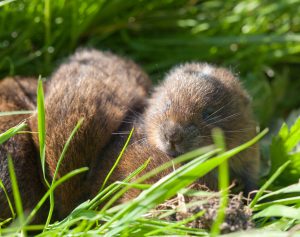 The watervole is Britain’s fastest declining mammal. Water vole colonies can be found along much of the river, feeding on the lush vegetation and burrowing in the riverbanks. Volunteers survey the population every other year.
Visit
The Chess Valley Walk is an extremely popular route through this valley. This 10 mile linear route takes in this beautiful valley and is conviently served by Metropolitan Line stations at either end, and along the way.
Get involved
![]() The River Chess Association delivers practical habitat improvements, educational visits, and guided walks and events to raise the profile of the river and highlight the issues it faces. The association co-ordinates riverfly monitoring on the river to assess water quality. They are also active in campaiging. For more information see
The River Chess Association delivers practical habitat improvements, educational visits, and guided walks and events to raise the profile of the river and highlight the issues it faces. The association co-ordinates riverfly monitoring on the river to assess water quality. They are also active in campaiging. For more information see
River Misbourne
 The R. Misbourne is 27km in length and falls 90m over this distance. Its traditional source is Mobwell Pond, north of Great Missenden, although its source moves seasonally upstream and downstream. The river passes through Great Missenden, Amersham, Chalfont St Giles and Chalfont St Peter before joining the R. Colne near Denham.
The R. Misbourne has always suffered from low flows. In 1771 the mills on the river were forced to close for a long period due to lack of flow. This drying not only effects the winterbourne section at the head of the river, but also the middle section from Amersham to Chalfont St Peter.
There are two main factors which explain the drying of the middle section. Firstly local geology is important. North of Amersham the river flows over New Pit chalk, which is described as ‘hard white chalk with few flints’. South of Amersham, there is a change to Lewes Nodular Chalk, described as ‘soft white chalk with many flints’. The softer material is likely to be more widely fissured and hence more permeable than the Middle Chalk.
The second factor relates to historic modification of the channel, mainly for milling. In a number of places the channel has been raised on embankments to create the head of water needed to turn the mill wheel. Water finds its way back down to the chalk of the original channel bed wherever possible, so disappears from the surface.
Visit
 See the Misbourne Walks leaflet for 3 varied routes along the river. Popular visitor sites include Missenden Abbey Park, Shardloes Lake and Denham Country Park.
Get involved
Two voluntary groups work to protect and conserve the River Misbourne.
The Chiltern Society River and Wetland Group campaign on local chalk streams. The chiltern society also run a number of more general conservation volunteering, which ocassionally get involved with chalk streams projects.
https://chilternsociety.org.uk/rivers-wetlands/
Misbourne River Action run practical volunteering days, particularly on the section of the river between Amersham and Chalfont St Giles. This group also co-ordinates riverfly monitoring on the Misbourne.
http://www.misbourneriveraction.org/
River Wye & Hughenden Stream
 The River Wye rises north west of West Wycombe in the Radnage Valley and flows south east for approximately 17km to join the River Thames at Bourne End. The Hughenden Stream, sometimes called the Hitchin, is a tributary of the Wye which rises near Cryers Hill. The upper reaches of the Wye near West Wycombe and much of the Hughenden Stream are winterbourne and often dry up in the summer months.
Hidden River
in 1967, as part of the ‘modernisation’ of the town centre the River Wye was diverted through underground pipes for around 840m of its length. At the time the Wye was a polluted river and there was some public support for removing it from sight. The Hughenden stream also enters a culvert for the last section of its length, meeting the Wye somewhere underneath the large Sainsbury’s in Wycombe town centre.
This culverting means a significant section of river is devoid of life, and also presents a series barrier to wildlife movements up and down river.
Visit
 The upper reaches of both rivers flow through National Trust properties – Hughenden Manor and West Wycombe Park. Further downstream the Wye flows through a number of public parks – Desborough Recreation Ground, The Rye, Kingsmead, Wooburn Park and Bourne End Recreation Ground – so is easily accessible.
The recreated Pann Mill celebrates the heritage of mills on the Wye. It is operated by the Wycombe Society and opens to the public on selected days through the year.
Get involved
Friends of the River Wye
This local groups runs practical volunteering days, wildlife recording programmes and events throughout the year. For more information or to become a member see https://revivethewye.org.uk/friends-of-the-wye/
Chiltern Rangers
Chiltern Rangers are a Wycombe based community interest company. They run weekly practical volunteering activities, which include river restoration and river litter picks. They also run special events for community groups, businesses and schools.
Hamble Brook
 The Hamble brook rises from a chalk spring north of Skirmett and slows south to join the River Thames at Mill End. When groundwater levels fall further the entire river can dry. The Hamble brook is a naturally ephemeral river.
Visit
There are a number of footpaths which take in the beautiful Hamble valley.
- The National Trust’s ‘Hamble Valley, Turville and Fingest’ circular walk follows the brook upstream starting in Hambleden.
- The Hambleden and Medmenham circular walk takes in the brook downstream of Hambleden, along with a section of the Thames path.
- The Hamble is also visited by the 200km long ‘Chiltern Way‘.
Ewelme Brook
 The Ewelme Brook is a small Chilterns chalk stream that rises east of Ewelme village in South Oxfordshire. It flows for about 4km in a westerly direction to meet the River Thames at Benson.
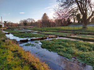
Watercress production was a thriving local industry throughout much of the 20th century, and Ewelme Watercress Beds supplied markets as far away as Covent Garden. The beds are now run as a heritage site by the Chiltern Society.
Visit
Ewelme Watercress Beds
Public parts of Ewelme cressbeds reserve are free to visit and open all year. There are monthly guided walks to allow visitors a chance to visit the closed part of the site. See Chiltern Society for details.
Get Involved
The Chiltern Society hold volunteer workday at Ewelme watercress beds on the first Saturday and third Wednessday each month. Email getinvolved@chilternsociety.org.uk or phone 01494 771250 for more information.
Benson Nature Group run conservation volunteer activities, talks and family events along the brook in Benson. This group also co-ordinates riverfly monitoring on the Brook, which helps monitor the health of the watercourse. See https://www.bensonnaturegroup.com for details.